Thursday, November 24, 2011

Bangladesh Country Profile

Banglades Map

If you ever wanted to experience the living reality of the idiom 'when it rains, it pours', Bangladesh is the place to be. During the yearly south Asian monsoon, almost all the water collected by the Himalayas in Nepal, north/northeast India and Bhutan transits through Bangladesh on its journey to the Bay of Bengal, depositing life-giving minerals to the soil all along the Ganges Delta, the largest river delta in the world. It is here that the mountains literally crumble to the sea. This has resulted in Bangladesh's flatland alluvial topography, which is the defining characteristic of the country except in the hilly regions of the southeast and northeast. The mighty Ganges and Brahmaputra rivers are called the Padma and the Jamuna in Bangladesh, and both of these massive rivers join several other smaller tributaries to eventually become the Lower Meghna, forming the great Gangetic Delta. At its widest point near Bhola Island, the river stretches to a yawning 12km-vide breadth on its final leg towards the sca. Se-2n _`-cm a boat, the distinctions between land, river, ocean and sky become decidedly uncertain.
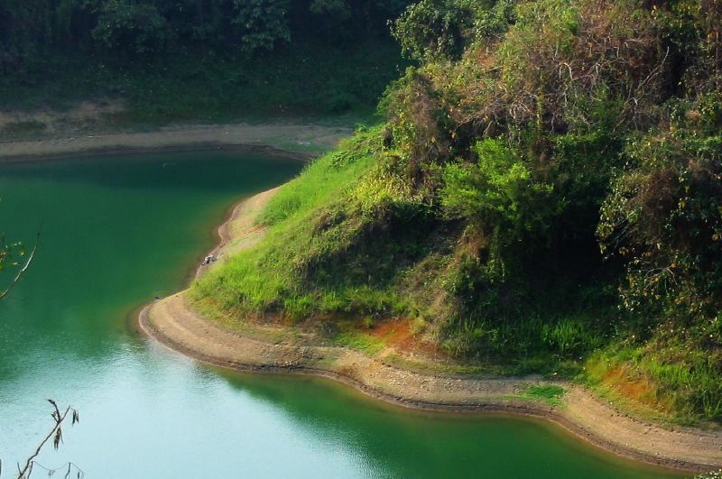
As the rivers have gradually shaped and reshaped this land, they have shaped the destinies of its people. It would be a mistake to picture the historic locations of Bangladesh's rivers according to current maps. For instance, the Brahmaputra used to flow east of Dhaka's present location before a major flood caused it to change course over a 30-year span during the mid-18th century. Simultaneously, the Ganges has also undergone similar changes, as it used to flow through West Bengal via the Hooghly River (today much smaller than it used to be).

Nowhere is this destiny more uncertain than in the country's two disaster-prone areas. Firstly, the coast bordering the Bay of Bengal is vulnerable to tidal surges from cyclones. Secondly, the country's char areas, or river islands, are also extremely prone to seasonal flooding. These islands lie mostly in the northern reaches of the Jamuna River of Rajshahi Division; many inhabited islands are destroyed and reformed each year by flooding. Despite the fact most of the islands are little more than infertile sandbars, poverty forces millions of people to live on them under the risk that their houses could be swept away each year.

In the Lower Meghna region, another area of exposure lies directly adjacent to the Bay of Bengal. Here, two processes of land loss and land accretion happen simultaneously. While the Meghna tears away strips of land beneath the villages each year, its decreasing speed causes it to deposit massive amounts of Himalayan silt into the bay, forming new land that becomes populated almost immediately despite the fact that the precious land doesn't become fully fertile for years. Some geologists even claim that Bangladesh is 'gaining landmass', putting the supposed doomsday scenario of climate change into question.

Where the land ends, the Bay of Bengal begins. Most of the sea adjacent to Bangladesh is quite shallow, a result of sedimentation from the region's mighty rivers. About 50km of the coast from the Sundarbans Forest is a deep undersea canyon known as the 'Swatch-of-No-Ground', where the sea floor drops to a depth of over 1,200m at some points. The swatch transports nutrient-rich sediments from the continental shelf to the deep-sea alluvial fan making up the bay. The abundance of these nutrients results in a relatively abundant population of cetaceans at the swatch.

In terms of forest cover, Bangladesh's natural places are sadly few and far between. While the world's largest mangrove forest at Sundarban remains protected, many of Bangladesh's other national parks have not fared so well. Thankfully, with increasing stability and economic development, conservation programmes are finally starting to get off the ground.

As you start travelling eastward, Bangladesh's geographic portrait takes on a new perspective. While most of the country lies at or just above sea level, the flat landscape gives way to low undulating hills in the Chittagong Hill Tracts and the hilly regions of Sylhet, some of which climb to 1,000m above sea level. This landscape is the result of the Indian tectonic plate pushing up against the Asian landmass, the same phenomenon that has resulted in the creation of the Himalayas. Visits to this area offer an experience of the true diversity that Bangladesh possesses, both geographically and culturally.

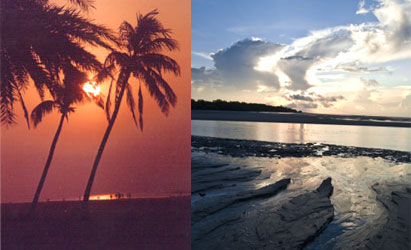
Finally, the region's last major significant geographical feature is a massive 120krn-long strip of beach lining tile internal eastern coastline of Bangladesh, said to be the longest natural beach in the world (at 254km, Brazil's Cassino Beach is longer, but according to the Guinness Book of World Records, it is partly manmade). Starting at Cox's Bazaar, the white sand stretches all the way down to the Teknaf Peninsula, poking up again briefly at the coral reef island of St Martin's. Most of this beach lies undeveloped except at Cox's Bazaar, where native mangrove forests have long been replaced by jungles of hotels.

Kaptai Lake

Kaptai Lake

A pleasant and picturesque drive of 64 km. from Chittagong brings you to a huge expanse of emerald and blue water ringed by tropical forests. It is the famous man-made Kaptai Lake (680 sq. km.). From Kaptai along the Chittagong road, lies the ancient Chit Morang Buddhist temple having beautiful Buddhist statues.

Bandarban

Bandarban Hill

Bandarban, the district headquarters of the Bandarban Hill District, is situated ninety-two km. from Chittagong. Bandarban is hometown of the Bhomang chief who is the head of the Mogh tribe. The simple and hospitable Moghs are of Myanmar origin and Buddhists by religion, jovial and carefree by nature. Bandarban is also the home of the Murangs who are famous for their music and dances. The highest peak of Bangladesh-Tahjin dong (4632 ft)-is located in the Bandarban district.

National Poet's Kazi Nazrul Islam

National Poet

It is the place where innumerable boyhood memories of our national poet Kazi Nazrul Islam are found around. It is situated 20 km. away from Mymensingh town. Nazrul was a student of Darrirumpur High School under Trisal police station. Here a cultural organization styled as Nazrul
Nazrul composed nearly 4,000 songs, collectively known as Nazrul geeti (Nazrul songs), which are still widely popular today.
Academy has been established in memory of the great poet. Rebel poet Kazi Nazrul, the shelley of Bangladesh is in eternal sleep besides Dhaka University Central Mosque.
Revolutionary poet Kazi Nazrul Islam died on 29th August 1976 and was buried here. The graveyard is adjacent to the Dhaka University Central Mosque.

Wednesday, November 23, 2011

High Court Building

High Court Building

Originally built as the residence of the British Governor, the High Court Building illustrates a fine blend of European and mughal architecture. The building is situated North of the Curzon Hall of Dhaka Universiry

Baldha Garden

Baldha Garden

Established in 1904, by the late Narendra Narayan Roy, the garden is located in Wari (opposite to the Christian cemetery). This garden boasts a rich collection of indigenous and exotic plants. Open: Saturday-Thursday, 9:00 a.m.-5:00 p.m. Friday closed. Entry tickets are available on the gate. Baldha Garden is most beautiful place. Many tree in this garden. Every day many people came to here and they enjoy it very much.

Bahadurshah Park

Located at old city opposite the Jagannath University formerly Victoria Park this memorial place of 1857 was built to commemorate the martyr's of the first liberation war in the years of 1857-59 against British Rule. This is the place where the revolting sepoys and their civil compatriots were cowardly hanged. The ancient name of the place was "Antagor Maidan".

Victoria College in Comilla

Victoria College

Victoria College is sited at Comilla in Chittagong Division. It is one of the oldest college at Comilla, and also Chittagong Division. Well-known landlord of that time Roy Bahadur Ananda Chandra Roy established this prominent institution after the name of Queen Victoria. For his contribution in education sector, he was given the title Roy Bahadur, a title which was given from the British ruler.

Panam Nagar-a ruined city of Sonargaon

Panam City

Panam Nagar or Panam City is an earliest city of Sonargaon thana in Narayanganj district, about 2.5 kilometers to the north of Dhaka-Chittagong Highway at Mograpara Point. Panam is only 0.5km away from Sonargaon Folk Art Museum. It is seemed to have been the city of Hindu capital city of Sonargaon. Panam Nagar, the gorgeous structures was rising in the last quarter of the 13th century. After that Panam area formed part of Muslim city developed on the old city, and perhaps made up the place of residence of the early Muslim governors.
When the Mughal took over the control of Sonagaon, they constructed highways and bridges and made a new look of Sonagaon and Panam City. Mughal era was the most significant era for all the region of sub-continent. Panam city has no different for this circumstances. Huge amount of construction works and developments in the life of city dweller had been occurring in the time of Mughal.


Some works of Mughal period still visible at present. Three brick bridges belonging to the Mughal period are: Panam Bridge, Dalalpur Bridge, Panam Nagar Bridge. Panam Bridgeis to be found at a little further to the east of Habibpur on a brick made road between Companiganj and Bari-Majlish, in Sonargaon. The bridge, constructed over Pankhiraj canal on a village road from Hajiganj to Baidyerbazar, belongs to the Mughal period. It consists of three archways, the middle arch being wider and higher. The first one is the smaller one and the last one is greater than the first one. DalalpurBridge, also the symbol of Mughal structurecrosses the Pankhiraj Khal (canel) on the northern side of Panam Nagar in Sonagaon and connects Adampur and Dalalpur. It has also three archways. It may be the tradition of Mughal artifact that the middle arch was made wider and higher for the secure passageway of boats. The path is made of bricks set in rounded lines. The bridge angles downward sharply on either side. The last one is Panam Nagar Bridge. It is a tiny one vaulted overpass situated on the western side of Panam Nagar in Sonagaon.The Bridge, over a narrow channel, attaches Panam Nagar with the main road.

A group of Hindu talukdars chose this place as their residence. The existing brick buildings of Panamnagar were the residence of the Hindu merchant-talukdars. Panam Nagar which developed in the nineteenth century continued to prosper till the end of the Second World War. Panam Nagar, a unique township, Fifty two houses exist in on its last legs and abandoned condition having 31 in the north side of the street and 21 on the south. Panam Nagar appears to be well protected by artificial canals all around. Two fairly large canals run parallel to the street on its either part and connected by a narrow canal on the western side over which is the entrance bridge.


The building structures in Panam Nagar are both separated and joined types, typically rectangular in shape and extended in the north-south direction. Height of the buildings varies from single to three storied. According to building layout design the residence houses of Panam can be categorized into three basic types: central hall type, central courtyard type and consolidated type. Here you also find a large size of house having 204 rooms in it. It is a private property of Mr.Abdul Awal who brought this house from the inheritor of Jamidar Ram Mohan Poddar in 1971. Panam had overall been a Hindu populated area. The migration of the Hindus to India after the Indo-Pak War of 1965 and Muslim-Hindu riot has made Panam Nagar into a vacant community.

Wednesday, October 26, 2011

Maheshkahli Island of Cox's Bazar

Moheshkhali

Moheshkhali is an island off the coast of Cox's Bazar. It has an area of 268 square kms. Through the centre of the island and along the eastern coastline rises a range of low hills, about 100 meters high. In the coastal hills lies the old temple of Adinath, dedicated to Shiva, which becomes a place of pilgrimage during the month of Falgun (March).
Tourists can reach this island by local motorboats called trawlers or by speedboat. By trawler, it takes an hour and a half and by speedboat only half an hour. Tourists will find interesting sights like mangrove forests, hilly areas, salt fields etc. This island is famous for its Buddhist Temple or Pagoda; a whole day can be spent sightseeing if one includes visits to Sonadia and some other nearby islands.

Lake and Hills in Rangamati

Rangamati

It is arguably one of the most picturesque tourist destinations in Bangladesh, ringed by numerous hills and situated right on the sparkling waters of Kaptai Lake. The colorful lifestyle and culture of the indigenous communities reveals signifies their inherent love or nature and their intimate bond with the hills, forests and rivers. Rangamati's majestic natural beauty is most attractively manifested in the rainy season - trees become greener, waterfalls are in full flow, the river Karnaphuli is full to the brim. Rangamati includes the following places or interest for the tourists:
The man-made Kaptai lake, spreading over 680 sq km of crystal-clear water was formed by damming the Karnaphuli river, and has a picturesque hinterland of large hills and panoramic forests. A cruise on the calm waters of the lake can be a memorable experience. The Chakma King's Palace is worth a visit.


Among other places of interest, Rajbon Bihara Pagoda located on a hilltop, attracts a large number of devotees who come for the religious occasion known as "Kathin Chivar Dan". Pedatingting. 5 km from Rangamati town at the mouth of the Shuvolong Channel, is an enchanting island resort located in the middle of the magnificent Kaptai Lake; with a beach frontage all around. The restaurant is clean and quiet, with an adjacent leisure park where tourists may enjoy the blue waters of the lake and the lush green of the hills. The restaurant has some delicious tribal-style dishes to offer. While visiting Rangamati, tourists may also go shopping at the Kalpataru Shilpaniketan, an ivory handicrafts centre in the town.

Stone Collecting in Tamabil

Stone

Situated amidst a splendid panorama, Tamabil is a border outpost on the Sylhet-Shilong Road, about 55 km away from Sylhet town. Besides the enchanting views of the area one can also have a glimpse of the waterfalls across the border from Tamabil. Nearby Jaflong is a scenic spot amidst tea gardens, where one can see stones that have rolled down the hills.
The stones are used for road and building construction, household uses and as souvenir. Stone crushing industries have also come up recently. The activities create air pollution, river shifting and bank erosion and land slides in the hill slopes.

Monday, October 24, 2011

Kuakata Beach for Sunrise and Sunset

Sunrise

It is a rare beauty spot at the southernmost tip of Patuakhali district. It has a wide sandy beach which affords one the unique opportunity of watching both the sunrise and the sunset. Kuakata is a place of pilgrimage for the Hindu and Buddhist Communities. Many devotees arrive here during the festival 01 Rush Purnima and Maghi Purnima. People came this place and they enjoy it very much.

Teknaf of Bangladesh-Southermost District

Teknaf

Teknaf is the southernmost district (upazila) of Cox’s Bazar district as well as Bangladesh. It is a small township on the Naf river at the end of the hilly region. It is an amazing place facing the green hills of Myanmar across the Naf River. One of the major attractions of Teknaf is a cruise by boat or sampan. Teknaf beach is an attractive tourist spot. Besides, there is another beautiful beach at Shahpari dwip at the farthest end of this upazila.

Rangamati, Khagrachari, Bandarban

Rangamati

The three hill districts of Rangamati, Bandarban and Khagrachari offer beautiful spots, where nature has been least disturbed. Far from the congested, polluted and busy areas of the plains, there scenic and calm spots offer rare opportunities to the tourists. These areas are inhabited by various tribes, who are still very simple, docile and hospitable.
RANGAMATI - the heart of the lake district
From Chittagong a 77 km. road amidst green fields and winding hills will take you to Rangamti, the headquarters of Rangamati Hill District, which is a wonderful repository of scenic splendours with flora and fauna of varied descriptions. The township is located on the western Bank of Kaptai Lake. Rangamati is a favourite holiday resort because of its beautiful landscape, scenic beauty, lake, colourful tribes (Chakma, Marma etc ), its flora and fauna, tribal museum, hanging bridge, homespun textile products, ivory jewellery and the tribal men and women who fashion them. For tourists the attractions of Rangamati are numerous, tribal life, fishing, speed boat crusing, water skiing, bathing or merely enjoying nature as it is. It is a rare spot for eco-tourism.

Himchari- Sea Beach in Cox's Bazar

Himchari

It is located 18 km south of Cox's Bazar, along the beach. The broken hills and waterfalls here are unique. There is a hilltop resort from where the shore of the Bay of Bengal looks enchanting. The scenic beauty one can see while driving from Cox's Bazar to Himchhari- is quite extraordinary, with lovely green hills on the left and the blue waves just on the right. The waterfall in Himchhari appears lively during the rainy season.
Besides, the longest sea-beach, Cox's Bazar and its adjoin areas have a lot of things to see and places deserve visit by the tourists.


The Cox's Bazar Holiday Complex of Bangladesh Parjatan Corporation, the National Tourism Organization is an ideal tourist resort having a number of facilities for the visitors.

Sunset in the Sundorban of Bangladesh

Sunset

Sunset in the Sundorban is most beautiful. The Sundarbans, a World Heritage site, is composed of three wildlife sanctuaries, namely the Sundarban East Wildlife Sanctuary, Sundarban South Wildlife Sanctuary and Sundarban West Wildlife Sanctuary. The total area of the World Heritage Site is 1400 sq km out of which 910 km is land area and 490 km is water. A complex network of tidal waterways, mudflats and small islands with salt-tolerant mangrove forest, make up the three sanctuaries.

Sunrise in the Sundorban

Sunrise

A visit to Bangladesh would remain incomplete if the Sundarbans did not appear in the itinerary. It is situated in the southwest corner of Bangladesh. It is the largest mangrove forest in the world. Criss-crossed by creeks and canals creeping around thousand of islets that swell and sink with the tide in the Bay. The cluster of isles, the water­-bodies and mangrove together support an eco-system at once unique with the result that the Sundarbans could be easily developed into a treasure house of biodiversity. It is home to 80% of reptiles. 40% of mammals' species and about 50% of all bird species found in Bangladesh. Of the 35 mangrove plant-species spotted in the whole world. 14 are found in the Sundarbans. The total area of the Sundarbans is 5772.85 sq km. The forest occupies 4016.85 sq km of land while rivers, canals and channels occupy 1756 sq km. Sunrise in the Sundorbans is the most beautiful, so many people came to the Sundorbans and enjoy it vvery much.

The Sundorban-Largest Mangrove Forest in the World

Mangrove

The Sundorban Largest Mangrove Lorest in the world . The Sundarbans, a World Heritage site, is composed of three wildlife sanctuaries, namely the Sundarban East Wildlife Sanctuary, Sundarban South Wildlife Sanctuary and Sundarban West Wildlife Sanctuary. The total area of the World Heritage Site is 1400 sq km out of which 910 km is land area and 490 km is water. A complex network of tidal waterways, mudflats and small islands with salt-tolerant mangrove forest, make up the three sanctuaries.

Sunday, October 23, 2011

Sundorbans-the home to thousand of birds

Bird

The forest is a bird-watchers' paradise as it is the abode of varieties of rare and colourful birds like the pond heron, kingfisher, cattle egret, little egret, golden plover, white-beaked vulture, fishing eagle, white-breasted eagle, red jungle fowl and so on. The noteworthy beauty spots of the Sundarbans are Katka, Kachikhali, Karamjal, Nilkand Hironpoint, Dublar Char etc.

Sundorbans-the home to Royal Bengal Tigers

Royal Bengal Tiger

The Sundarbans has been recognized globally, for its importance as a reservoir of biodiversity. The mangrove supports a unique assemblage of flora and fauna. Including, charismatic mega fauna like the Royal Bengal Tiger, the estuarine crocodile and the Ganges river dolphin or susu. The Sundari tree. after which the Sundarbans is named, is native to this forest.
The attractions of this forest are varied and many wild unspoiled and unpolluted beaches are scattered here and there along the borderline of the Bay. The flora of the Sundarbans includes Sundari, Keoral, Gewa, Golpatal, Goran and Passur. The fauna can boast the legendary Royal Bengal Tiger, spotted dear. Squirrel, rhesus monkey, barking deer, wild boar, dolphin etc. Of the reptile species there are the estuarine crocodiles, pythons, lizards, flap-shelled spotted turtles and green turtles.
The fish population has betki, rekhal, boncha, faissal, pangash, ritha, silon, hilsha, catfish, lobster, shrimp, prawn etc. The forest is a bird-watchers' paradise as it is the abode of varieties of rare and colourful birds like the pond heron, kingfisher, cattle egret, little egret, golden plover, white-beaked vulture, fishing eagle, white-breasted eagle, red jungle fowl and so on. The noteworthy beauty spots of the Sundarbans are Katka, Kachikhali, Karamjal, Nilkand Hironpoint, Dublar Char etc.

Tea Estate in Srimangal

Srimongal


Srimongal is famous for having the largest tea gardens in the world. Covered by the lush green carpet of tea plants, it is called "the land of two leaves and a bud". Tourists can have a look at the terraced tea garden and pineapple, rubber and lemon plantations. The visitor to a tea estate is greeted by sweet smells and a pretty landscape that will beguile the imagination. About 80 km from Sylhet town and connected by road and rail. Srimongal is known as the capital of Bangladesh. A visit to a tea plantation in Srimongal is a memorable experience. The visitor came this place and they are enjoy it very much.

Sri Chaitanya Temple of Bangladesh

Sri Chaitanya Temple is very nice place. About 500 years old famous temple of Sri Chaitanya Dev is located at Dhaka Dakshin nearly 45 km. south-east from Sylhet town. The place is revered for being the ancestral home of the famous Vaishnava saint. Yearly fair is organized on the full moon day of the bangla month Falgun. Hundreds and thousand of devotees from home and abroad attend this colorful fair.

Chandranath Hindu Temple

Sitakunda

The Chandranath Hindu Temple is very beautiful. It is approximately 37 km. far from Chittagong city. This is famous for Chandranath Hindu Temple - one of the oldest temples in the subcontinent. There is also Buddhist Temple having a footprint of Lord Buddha. These places particularly the hilltops are regarded as a very sacred by the hindus and buddhist. Shiva Chaturdoshi (14th) festivals is held every year in February when thousands of pilgrims assemble which lasts for ten days. There is also a hot-water spring 5 km. to the north of Sitakunda. Every year people visit in this temple and they are enjoy it very much.

Kantaji Temple of Bangladesh

Hindu Temple

The most ornate among the late medieval Hindu temples of Bangladesh Kantaji temple is situated near Dinajpur town. It was built by Maharaja Pran Nath in 1752. Every inch of the temple surface is beautifully embellished with exquisite terracotta plaques, representing flora and fauna, geometric motifs, mythological scenes and an astonishing array of contemporary social scenes and favourite pasttime. The Maharaja's palace with relics of the past and the local museum are well worth a visit.

This nava-ratna or 'nine spired' Hindu temple, now stripped off its original nine spires atop its corners during the devastating earthquake of 1897.

The 52 feet square temple is centered in an oblong court, 240 × 120 ft (73 × 37 m), covered by a shed with a roof of corrugated tin. Its main fabric pivots around a nuclear square cell (10 ft 3 in (3.12 m)), reaching a height of about 50 ft (15 m) above its 3 ft 3 in (0.99 m) high slab of stone, thought to have been mined from the ancient ruins of Bannagar near Gangarampur in Dinajpur.

Three more square outer shells in graded heights have been added to it, to variegate the plan as well as to strengthen the central sanctuary on top of the massive tower.

The curved cornice from the ground floor, which sharply drops at the corners, rises in the middle to a height of 25 ft 0 in (7.62 m) from the plinth, while the first floor cornice rises to 15' and the second floor to 6 ft 6 in (1.98 m). Small square cells are situated at the four corners of the ground and first floors.

They serve the purpose of supporting the weight of the octagonal corner towers above. The temple contains four rectangular alleys on the ground floor circling the prayer hall which measure 30 ft 8 in (9.35 m) by 5 ft 0 in (1.52 m) and 15 ft 6 in (4.72 m) by 4 ft 4 in (1.32 m). On the ground floor. Three multi-cusped arched entrances on each side are present, which are separated by two ornate brick pillars. The number of arched doorways in the ground floor in its four shells is 21; on the first floor it is 27. The second floor, reduced in size, has only three entrance doors and three windows. A narrow staircase, only 2 ft 3 in (0.69 m) wide, is built into the western second corridor. It winds up through the dark passage to the first two stories.

Saturday, October 22, 2011

Hazrat Shah Jalal(R.A.) and Hazrat Shah Paran(R.A.)

Sylhet Mazar

The great Muslim Saint, Hazrat Shah Jalal (R.A.) is said to have brought the message of Islam to the region in the early 14th ecntury. His shrine is located at Dargah Mahalla in the heart of Sylhet town.

 At about 6 km away lies the shrine of another great saint Hazrat Shah Paran (R.A.), who is said to be a nephew of Hazrat Shah Jalal (R.A.).

Sixty Dome Mosque in Bagerhat

Shait Gombuj Mosjid

Among the many surviving monuments of the Khan Jahan Ali style, undoubtedly the most magnificent and largest brick mosque in Bangladesh is the Shait Gombuj. It is situated in Bagerhat district. For outstanding architectural value. the World Heritage Committee of UNESCO inscribed Bagerhat in the World Heritage list and it got the status of the second World Heritage site in Bangladesh after Paharpur. As there were a great number of mosques, the Historian, a French monthly termed it a city of mosques. The earliest torchbearer of Islam in the south, Khan Jahan Ali came from Delhi to settle a Muslim colony in this swampland in the early-15th century AD. The natural beauty of the region had such an effect upon him that he spent the rest of his life there. History says that he constructed about 360 mosques and as many freshwater tanks, as well as palaces, mausoleums and other public buildings in a very short space of time.

Its name, meaning '60 domes', is misleading as in reality, it is roofed over with 77 small domes supported by a forest of slender columns covering a large prayer hall and giving it the appearance of a medieval church crypt. At sunrise when the rays of the sun penetrate the eastern entrances, the interior comes to life.The exterior facades, with slightly 'battered' walls, have discernible curving cornices a concession to the local style.

Friday, October 21, 2011

National Museum of Bangladesh

National Museum of Bangladesh


Bangladesh National Museum preserves and displays the cultural property and heritage, as well as specimens of natural history of Bangladesh. Its mission is to establish a bridge between the past and the present and uphold the national tradition and culture. The museum itself has a history, which began with the establishment of Dhaka Museum on 20 March 1913 with an annual government grant of Rs 2,000. The Governor of Bengal, LORD CARMICHAEL, formally inaugurated the museum on 7 August 1913 in a room of the Secretariat Building (at present, the DHAKA MEDICAL COLLEGE AND HOSPITAL).
The plea for setting up a museum in DHAKA was first made in the newspaper The DHAKA NEWS on 1 November 1856. In 1909, a few coins were transferred from Shillong to Dhaka, and a suitable place was needed to preserve them. H E Stapleton, a famous numismatist made a proposal to Governor Sir Lancelot Hare on 1 March 1910 to establish a museum in Dhaka.
In the first meeting of the general committee held on 3 March 1914, a decision was taken to request the Bengal government for a grant of Rs 5,000 to cover the development expenses of the museum for 1914-15. The first meeting of the executive committee was held on 19 May 1914. At this meeting the draft budget for the year 1914-15 was prepared and a decision was taken to appoint a curator. NALINI KANTA BHATTASALI joined as the first curator of Dhaka Museum on 6 July 1914, with a monthly salary of Rs 100. Although the museum was inaugurated on 7 August 1913, it was opened to the public on 25 August 1914, with 379 objects on display. A total of 4,453 people visited the museum in 1914-15; among them 143 were female.
A large portion of the budget of the museum comes from the government as grant. The sources of the museum's own income include the rent collected from the four auditoriums and other buildings and sale of entry tickets. The director general is the chief executive of the museum. It has four branch museums: Osmany Museum at SYLHET; AHSAN MANZIL Museum in Dhaka; Zia Smriti Museum in CHITTAGONG, and the Shilpacharya Zainul Abedin Sangrahashala at MYMENSINGH. The number of foreign and local visitors at the museum average 2,345 a day. For rural people, the museum organised a Mobile Exhibition in 1979 with a special bus containing a Mini Museum of 28 small galleries. The objective of this programme was to make the masses familiar with the culture and tradition of Bangladesh.
The important objects under the Department of Contemporary Art and World Civilisation include paintings and sculptures of Shilpacharya Zainul Abedin, Quamrul Hasan and artist S M Sultan and artworks and reproductions of works by renowned artists from home and abroad; potteries burnt during the Second World War in Hiroshima of Japan and various local and foreign objects collected from Bangabhaban.
Objects supervised by the Department of Natural History include mapping of rocks, minerals and population of Bangladesh; geological map of Bangladesh; water colour paintings of rural Bangladesh; stuffed Royal BENGAL TIGER of the Sundarbans, chitral deer, honey bee, PEAFOWL, CATTLE and birds, fruits and flowers, butterflies, pet animals, marine mollusc, elephant, monkey, LANGUR and the skeleton of a whale. Two other departments are Conservation Laboratory and Department of Public Education. The laboratory looks after the restoration of museum objects using scientific methods. The Department of Public Education conducts museum-related education programmes for the public and students. This department has seven sections: education, display, library, publications, audio-visual, auditorium and photography. The Department of Public Education organises seminars, symposia, exhibitions, competitions and educational and cultural functions.

Monday, October 17, 2011

National Memorial

Jatio Sriti Shoudho


Jatiyo Sriti Soudho (Bengali: Jatio Sriti Shoudho) or National Martyrs' Memorial is a monument in Bangladesh. It is the symbol of the valour and the sacrifice of the martyrs of the Bangladesh Liberation War of 1971, which brought the independence of Bangladesh from Pakistani rule. The monument is located in Savar, about 35 Kilometres north-west of the capital, Dhaka.

Plans for the monument were initiated right after the independence, in 1972. Following the site selection, road and land development, a nation-wide design competition was held in June, 1978. Following evaluation of the 57 submissions, Syed Mainul Hossain's design was chosen. The main structure and the artificial lake and other facilities were completed in 1982.

Language Martyr's Monument of Bangladesh

Shaheed Minar

The Shaheed Minar (Bengali: Shohid Minar) is a national monument in Dhaka, Bangladesh, established to commemorate the martyrs of the Language Movement of 1952.

On February 21, 1952, dozens of students and political activists were killed when the Pakistani police force opened fire on Bengali protesters who were demanding equal status to their native tongue, Bangla. The massacre occurred near Dhaka Medical College and Ramna Park in Dhaka. A makeshift monument was erected on February 23[1] by students of University of Dhaka and other educational institutions, but soon demolished on February 26[2] by the Pakistani police force.

The Language Movement gained momentum and after a long struggle, Bangla was given equal status as Urdu. To commemorate the martyrs, the Shaheed Minar was designed and built by Hamidur Rahman, a Bangladeshi sculptor. The monument stood until the Bangladesh Liberation War in 1971, when it was demolished completely during Operation Searchlight, a genocide carried out by the Pakistani Army resulting in an estimated 50,000 civilian deaths. After Bangladesh gained independence, it was rebuilt.

Sunday, October 16, 2011

Teknaf The Natural Beauty

Teknaf

Teknaf is famous and natural beauty for Hills, Naf River and Forest. By the side of Naf river you will sea a lot's of Salt fields there. that increases natural beauty. From Cox's Bazar you can come Taknaf. It's about 85 Km. Road journey. There You can see many shopping market. One is called BURMESE Market. From here you can shop Burmese & Tribal Hand made materials.
You will see there Wild animals and birds, but Journey on the river is the most interesting thing.
An enchanting scene is there that is Wide sandy beach in the backdrop of high hills with green forests that never to be forgotten.

Dulahazara Safari Parks of Cox's bazar

Dulahazara Safari Parks

Location: located on the eastern side of Cox's Bazar-Chittagong highway. Dulahazara Safari Parks is about 50.0 km nor from Cox's Bazar District Town and 10.0th km South from Chakaria Thana.This parks established 1999 and 600 hectare area in Cox's Bazar-Chittagong highway.Existing facilities : when you will go to Dulahazara Safari Parks, you will watch many animals and they are moving freely here and there in large areas. Dulahazara Safari Parks is a very promising area to develop eco-tourism with the development of existing facilities and addition of some semi-mechanical recreational arrangements. Every year 1,00,000 visitors come in this parks and they are enjoy very much. Dulahazara Safari Parks is most beautiful.

Cox's Bazar- The longest sea beach in the world

Cox's Bazar

Cox's Bazar, the most attractive tourist spots for Bangladesh and not only for Bangladesh it's the longest sea beach in the world.
Seventy-five miles (120 Kilo miters sandy sea beach with a gentle slop). and it's the the tourist capital of Bangladesh.visit beach is the main reason which is shark free and good for bathing, swiming & sun-bathing. Lot's of local tourist & foreign tourist come Cox's Bazar to spend their leisure in Cox's Bazaar.

Cox's Bazar is a small town. But the natural beauty of the town is very charming. The climate of this place is very fine. The Bay of Bengal lies on the south of it. There is a high standard tourist centre at this place. There are good arrangements for the stay of the tourists of different countries of the world. Many foreigners come to this place. The people of the place are very gentle. A lot of fish is available there.

Mosque Baba Adam

A slightly later date the elegant 6-domed mosque (13m x 11m) sq meters of Baba Adam in Rampal near Dhaka was erected by your Malik Kafur during the reign of the last Ilyas Shahi Sultan, Jalauddin Fateh Shah in 1483 AD. It displays the same characteristic features of the period such as the faceted octagonal turrets at 4 corners, the curved cornice. The one facade and 3 mihrabs relieved richly with beautiful terracotta floral and hanging patterns. But anythin special or historical is know about him excpet the popular tale of his fight with Ballal Sen.

Chhoto Sona Mosjid in Rajshahi

Small Gold Mosque

One of the most graceful monuments of the Sultanate period is the Chhoto Sona Masjid or Small Golden Mosque at Gaur in Rajshahi. Built by one Wali Muhammad during the reign of Sultan Alauddin Husain Shah (1493-1519), it was originally roofed over with 15 gilded domes including the 3 ChauchaIqa domes in the middle row, from which it derives its curious name. Bangladeshi people call this mosque name by Chhota Sona Masjid.

Star Mosque

Star mosque, a 19th century establishment, is a very beautiful mosque of the city situated at Armanitola, in the old part of Dhaka City. In faultless Mughal style architecture, it is a five­-dome mosque with hundreds of big and small twinkling stars as surface decorations. The stars have been created by setting pieces or chinaware on white cement. Seen from the front and from far it looks as if it were shining above the surface of the earth. The inside or the mosque is even more beautiful than the outside, with a lovely mosaic floor and excellent tiles with many floral patterns set on the walls, all in complete harmony. The star mosque bangla name Tara Mosjid

National Mosque of Bangladesh

It is the National Mosque of Bangladesh. Its construction began on 1960, and has been going on in phases. Architect T Abdul Hussain Thariani was commissioned to design the mosque complex. The plan included shops, offices, libraries and parking areas within the complex. The design of the mosque reflects the architecture of the period as can be seen from the use of a white and almost cube-form for the main building. A Mosque without a dome over the roof of its main prayer hall must have been a unique experiment. The main building is eight storied and 33 meters high from the ground level. The area of the main prayer hall is 2464 SQ meters with a mezzanine floor of 171 SQ metres at the eastern side.The mihrab of the hall is rectangular instead of semi-circular. The Baitul Mukarram mosque is modern in its architectural style. It has found its place in the hearts of the Muslims because of the resemblance of its form to the Holy Kaaba at Makkah.

Thursday, October 13, 2011

THA NATIONAL ZOO IN MIRPUR

Dhaka Zoo

Dhaka Zoo is located in Mirpur area of Dhaka city. It was established in 1964, as a menagerie at the High Court Premises. In 1974 it has been moved to the present location under the supervision of Fisheries and Live stocks Department. It has an area of 186 acres including two lakes, which are the sanctuary of migratory birds in winter season.
Though varieties of faunae are in Dhaka zoo, the present condition is not so optimistic. Many of them are suffering from malnutrition. In last few months, above 30 of precious animals died, including lion, tiger, zebra, giraffe and rhino. Negligence, inadequate care, inexperience and poor living condition may be the causes of deaths.

This is the national zoological garden of Bangladesh. About 2200 animals of 157 species are dwelled and about 10,000 people visited the zoo everyday, and the people enjoy very much. So the government should pay extra attention to run it appropriately.